
Snowdonia Grade 3 training, 4th - 7th April 2016
DAY 1
Buzz, buzz, buzz, across the bunkhouse, as several mobile phones inform us that it is time to get going for Day 1 of our Grade 3 Training. A hive of activity, several showers, sandwiches prepared and ultimately we are all out for 08:30 (well nearly) as Tom had requested.
Into the minibus we go, the day is looking okay. Not
exactly blazing sunshine but visibility is good and the mountains of Snowdonia
look fantastic. We travel for a little while and the scenery starts to change. ‘You do realise we are driving away from all the mountains here Tom?’ says a
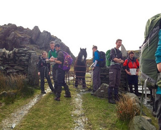
perplexed Lee. Suddenly after 40 minutes we stop. Off the bus and its relocate
time. Essentially, find yourself on the map, not a lot to go on here haha, a
railway line, a lake, an arterial road and a welcome board to a specific area. So
we all knew where we were (Rhyd-Ddu) and I guess if we failed here it was going
to be a long week! However, we enjoyed it while it lasted for now we were going
into the world of micro-nav and detailed micro-nav at that, where we expected
to give several reasons to one of the leaders as to why we were specifically in
this precise location.
 We were split into pairs, and the leaders explaining how teamwork is so important; that when leading a Ramsoc walk we will primarily work in pairs and so it is a useful skill to have. It was James Smith and Military James (sorry, no heroic tale to tell here, I do believe he is destined for great things though) turn to lead after being shown a point on the map. The rest of the group put our maps away and we followed the two James’. Continuing along the bridleway everything appeared fairly straightforward and suddenly they stop. They have a small discussion and then they leave the path and venture across the boggy ground. The two James’ debate for a while and they call one of the four leaders across (Tom Howe, Aneurin Davies, Andy Pickup and Louisa Cox) to explain why they believe they are in the right location. Once this is confirmed, the rest of our group take out our maps and it now our chance to relocate.

However, this was to be the exact location. It was no
longer useful to say we can see Llyn Cwellyn reservoir from here or Y Garn
Mountain to give us an approximate location and then narrow it down with
boundary features. The premise of this training was to look at a more immediate
area and primarily to put into practice three skills for gaining location. Remembering
our journey (what we had seen along the way), pacing ( how many double steps it
takes to travel 100m, which varies for everyone but is exceptionally useful)
and the use of contours. Contours being particularly important, as the leaders
explained, land features will change and maps become dated but contours should
be the same. Tom was to further show this fact later when he showed us a 1:50K
map which lacks the boundary features of the 1:25K and yet we could still
locate ourselves adequately using the contours and other natural land features.
Once relocation had been verified, it was then the turn of the next pairing.
This pattern of leading in pairs to a new location and establishing known location was to continue throughout the day as we made our way along the bridleway and public footpath until we attained the summit of Snowdonia. Whilst it had taken a while to summit the mountain, the wealth of knowledge we accrued along the way was truly remarkable and as we stood on top of the summit, seeing the lovely views of mist, we could be proud of gaining extra skills. We made our way down the mountain and had been asked approximately how long it would take to descend the mountain. Two hours in total, with a brave Lee stoically refusing to let the pain of his ankle hold him back after his unfortunate lunchtime slip on a rock I had literally just stepped on!

Back to the bunkhouse we went, where Tom Howe and his
helpers produced a fantastic chicken curry and then the lads rolled up their sleeves
and kicked into action doing the washing up. We all got refreshed and then at
21:00 we split into groups and partook in theory led by Tom as to the
responsibilities a grade 3 leader would have. A great day was had but we were
all certainly ready for our beds!
David Park
DAY 2
Tuesday dawned for the RAMSOC trainees and brought with it the rope work
section of the Grade 3 training. The first part of the section was all about
finding suitable ground anchors (technical term for a rock!) that we could tie
a rope to. In order to test a rock’s suitability various techniques had to be
carried out including kicking the rock to see if it would move or wobble. For
this reason, the name quickly changed from ‘rope work’ to ‘the rock kicking
course’. After this we were sent in pairs to practise body belaying which
involves using a rope to ensure somebody’s safety on a steep ascent or descent.

Thanks to some great techniques from Tom and Neu, you can rest assured
that your grade 3 walk leader will know what to do.

Straight after our Mountain Rescue visit we had the night Nav part of
the training. This involved using techniques learnt during the micro Nav
exercises during the day but with the limitation of only being able to see as
far as our torches would reach. We were split into pairs and had to come up with
a plan to get to a chosen position on the map. Afterwards, a well deserved hot
dessert and a few hours rest ready for the adventures of Wednesday.
James Pailing
DAY 3
Fresh from
our nighthike the night before we had a leisurely breakfast in the bunkhouse
before leaving for our day out on the hills. We set off in the minibus and parked
at Idwal cottage, a place now very familiar to us after our escapades the day
before! The car park was less full than yesterday – a forecast of bad weather
had put many people off walking today!
Kitted up
in many layers (well I at least had 6) and paired up to continue micro-nav we
retraced our steps up the path to where we were doing rope work on Tuesday. We continued past until we got to Llyn (lake)
Idwal and then paused for some relocation! The weather was still sunny but this
was soon to change…

We left
the lake, ascending on an unmarked path and crossing a couple of fast running
streams. Pausing for lunch we enjoyed the view of Llyn Idwal below and watched
the clouds draw in. The wind picked up speed and over the lake a small
whirlwind formed which was quite impressive to watch!
The next
part of the day was even more exciting; we were about to start a scramble up
senior’s gully. Since safety whilst doing a scramble is paramount our scramble
leaders Tom Howe and Neu carefully arranged us into an order we had to follow
the whole way up. After a short briefing on the finer aspects of the scramble
techniques we set off! There was a buzz of excitement and anticipation in the
air as Alex led us up into the gully. The journey up the gully was slow as everyone
helped each other up the more tricky sections but everyone seemed to enjoy
themselves and there were times when we could stop and enjoy the views!


Once back
at the lake we reconvened before practising some more micro-nav. This time we
went off the path over, you’ve guessed it, more mud. When Dan and I carried out
our micro-nav, practising the navigational art of leap-frogging 100 m at a time,
the mud did prove quite entertaining. Dan slipped straight down before our eyes
ending up with a spectacularly muddy bum! I couldn’t laugh for too long though
– the next morning the same happened to me!
The walk
held one more surprise for us after traversing the muddy fields. We descended
down some more rocks and found ourselves surrounded by sheer rock on both
sides, and behind us a lovely little pond. It was spectacular, and almost
cathedral like! Then, after hopping over a stile, as suddenly as we had
discovered it we left it and were back at the car park.

Louisa Cox
Comments
Post a Comment